 |
Landscape morphology has a direct
influence on water movements, soil physical and chemical properties and on the
productivity of the vegetation cover. Many studies have demonstrated the relationship
between landforms and productivity of phytocoenosis or cultures and it should be expected
that this relationship can be proved for remote sensing vegetation indexes. |
Remote sensing of rugged terrain
is hampered by topographic effects on spectral signatures. Hence, the effect of topography
on backwards radiance should be taken into account before considering the influence of
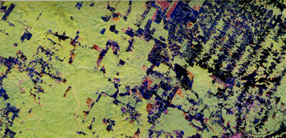
topography on vegetation. The "topographic effect" is easily observed in this
composite BGR of Landsat TM bands 3, 4 and 5 of the Valboreca site (one of the two sites
of the project in the northern Apennines): slopes facing the sun are brighter whereas
slopes facing the opposite direction are darker as a consequence of the different fluxes
of incident sunlight over a given area.
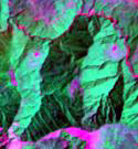
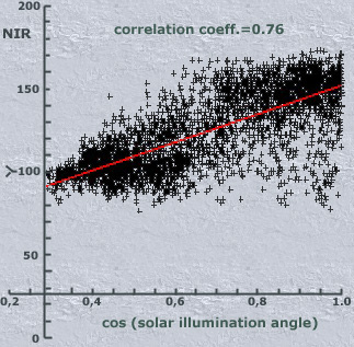
TM data topographic dependence can
be evaluated by calculating the correlation coefficients between the reflectance of a
given band and the cosine of solar illumination angle (i) - the angle regulating the
topographic effect, between the solar vector and the vector normal to the surface. The
Figure shows a correlation coefficient’s value of 0.76 between TM band 4 and the
cosine of solar illumination angle for the mixed deciduous forest area of the Valboreca
site, thus indicating that about 58% of the variance of NIR reflectance in this rugged
forested area is explained by the topographic effect. Several proposed algorithms use
Digital Elevation Models (DEMs) as the basis for topographic correction. The following
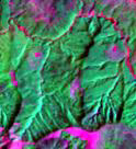
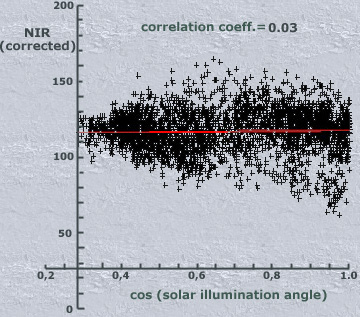
Figure, reporting the same data after the application of the non-lambertian Minnaert model
shows the effectiveness of the model at removing the topographic effect:
In spite of the reported
effectiveness topographic normalization methods are used infrequently, probably as a
consequence of the lack of high-resolution DEMs. This constraint may be removed upon
completion of the Shuttle Radar Topography Mission that will provide a huge SIR-C/X-SAR
interferometric DEM data-set.
The synergistic use of optical remote sensing data and Digital
Elevation Models at the same spatial resolution can be extremely helpful for the
evaluation of the influence of topography on productivity and therefore on vegetation
indexes of forested ecosystems. A better comprehension of this relationship would benefit
the inventory of forest resources as well as the evaluation of potential land productivity
in areas of relief and of limited cartographic coverage. The project proposed by CRAST (Centro Ricerca Analisi
Spaziale e Telerilevamento- Universitŕ Cattolica del sacro Cuore) will use SRTM DEM data
for the Minnaert topographic normalization of Landsat TM data of two forested areas in the
northern Apennines (mixed deciduous forest and beech forest). Forest cover information
such as structural/floristic composition will be collected for the beech test area by GPS
survey. NDVI and other vegetation indexes derived from the corrected TM data, will be used
as dependent variables in multiple linear regressions against landscape morphology
parameters, obtained from the SRTM DEM, that can affect vegetation productivity. Among
these parameters, elevation, slope, landsurface curvature and catchment area will be used
as independent variables. |