The research objective is twofold
 For the first time, possibilities for Synthetic Aperture Radar (SAR) to
survey data useful for management and planning of urban areas
are to be explored. |
 |
|
The morphostructure of some areas where
measurements of on-ground facts are available will be analyzed. |
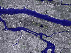
Urban areas
How a Synthetic Aperture Radar works is familiar to specialists in the
sector. For those coming to this remote-sensing sensor for the first time, SAR's operation
can be schematically explained as follows:
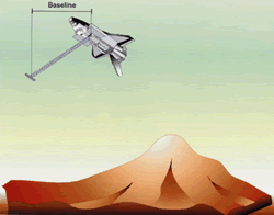 |
the SAR is a radar that transmits an electromagnetic signal; this signal
propagates from the satellite carrying the sensor to the area of Earth under observation;
the signal, like a wave of the sea hitting a rock, is reflected from the Earth area
observed, and part of the reflected signal goes right back to the sensor that transmitted
it. |
The idea suggests itself that the signal that comes back
to the sensor should retain traces, that is, have characteristics that depend on the
configuration of the Earth area observed. Accordingly, by receiving the return signal at
the sensor and appropriately processing it one can in fact manage to obtain images of the
scene observed that can be seen as microwave "photographs".
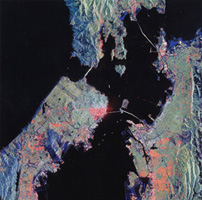
Some websites in the world are rich in these microwave photographs (NASA, ESA)
that show how this sort of sensor can manage to supply images that show aspects that
complement optical imagery, but with much more interesting resolution (in this connection
see the optical images from Ikonos sensor).
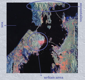
In these images it is easy to recognize seas, lakes, rivers, roads. It
is somewhat harder to manage to recognize mountains with their shapes; built-up areas,
which appear very bright, can also be recognized, but it is very hard to identify
individual buildings..
The previous diagram helps us to understand why: in the case of
buildings, the signal is reflected twice. The first, for instance, is from the side walls
of each building, which are smooth and reflect the signal, as a mirror does with a light
ray, towards the ground; the second reflection comes from the ground where, if the paving
is smooth enough, almost all the signal is directed back to the sensor. The twofold reflection thus has the power to concentrate the signal
almost entirely back in the direction it was transmitted from, which explains why urban
areas appear very bright in SAR images. At the same time the signal received does retain
traces, unfortunately overlapping, of the building and the surrounding paving. Just as
with a photo frame exposed twice with two different subjects, it is hard to separate these
two contributions and reconstruct even one of the two original images.
The research the group proposes will seek specifically to study these
reflection effects, understand the origin of the overlapping contributions and identify
techniques enabling more comprehensible microwave images of urban areas to be made.
The group is organized as follows: the
universities of Naples and Florence
swill study the mechanisms of interaction between the SAR signals and urban areas, create
theoretical models and carry out simulations of the type of city image to be expected from
X-SAR/SRTM; the university of Pavia will use the models
proposed and seek to extract information on built zones by working on the data actually
gathered by X-SAR/SRTM..
For those wanting further details
The research in the area of remote surveying will be done by the
universities of Naples, Florence and Pavia. A model of the electromagnetic signal
diffracted from buildings will be developed and inserted into a simulator of the RAW
signal.
The results of the simulation will be used to define the information
that can be extracted from SAR images and from interferograms of urban areas. The
identification of constructions in urban areas will be checked on, and the quality of DEMs
in built-up areas assessed.
The university of Pavia will have available direct-scattering models it
will use to train neural networks specialized for inverting the diffracted field.
Automatic and semi-automatic tools will be designed to invert interferometric measurements
on urban areas. This will be used to validate X-SAR/SRTM data from densely built
environments, taking into account the materials, shape and density of buildings, and to
derive from the data themselves the greatest possible amount of information on complex,
crowded environments like cities.
To this end, among tools used will be neural networks specialized for
inversion of the diffracted field, and instruments will be developed to interpret the
images, making use of correlation of the radar measurements to identify such structures as
buildings and streets. Data from the Pavia group's previous experience in this area will
be taken as a basis. The test area should be the city of Pavia itself, for which
three-dimensional cartography is already available.
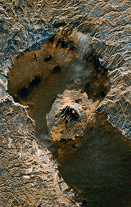
Morphology
What morphological information can be derived from the X-SAR/SRTM data?
Three geological areas of particular importance will be analyzed
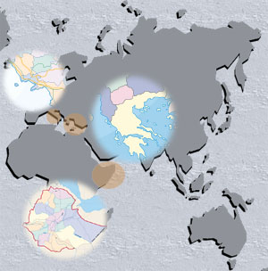 |
one of the areas of worst territorial degradation due to natural factors and human
settlement;
The area running from Scutari (Albania) to the Eastern
Peloponnese (Greece), for the search for oil;
Vesuvius,
an area at high volcanic risk
|
In each of these areas geological data will be surveyed
in association with the passage of X-SAR/SRTM to verify which are recognizable on the SAR
images. |