The activity coordinated by the IROE-CNR sees
participation of research groups from the following institutions: ITIS-CNR, Matera;
IESI-CNR Bar; Department of Physics, University of Florence; Massachusetts Institute of
Technology (USA); Centre d'Etudes Spatiales de la Biosphčre (France).
The research is aimed at assessing the effects of ground surface
characteristics on the SAR signal and on the height profile obtained from the
interferometric measurements. Interaction of the microwave signal with the ground is known
to involve both surface and volumetric scattering, and both amplitude and phase of the
back-diffused signal depend on the geometrical and dielectric characteristics of the
surfaces investigated. Much work has been done on correlating signal amplitude with
observed surface type, whereas there is only slight information on the influence of
surface characteristics on phase and coherence of the SAR interferometric signal. On the
other hand, on the basis of knowledge gained, we expect geometrical (e.g. surface
roughness) and dielectric (induced by ground humidity) variations in surfaces observed by
SAR to influence the interferometric signal. The research objective is accordingly to
assess the contribution of interferometric coherence and phase measurements to
classification of ground type, estimation of biophysical parameters of surfaces observed
and assessment of penetration of vegetation-covered areas, to reduce error in height
measurement.
The test areas
The test areas will be Matera (southern Italy), Montespertoli (central
Italy) and Araude (southern France). In each of these areas experiments have already been
done with various SAR systems (AIRSAR, SAR 580, ERS-1/2, JERS-1), so that a broad series
of data is available, from both remote sensing and "ground truth".
The Matera site, the same one as used for the calibration experiment,
is an agricultural area sown mainly to wheat, in winter with many bare fields in various
conditions of surface roughness. The area of Montespertoli, near Florence, consists of the
basin of the river Pesa with its small tributary Virginio. It is typical of the climatic,
lithological and vegetation conditions of many agricultural areas in central Italy.
Various types of cultivation are present, including vineyards and olive groves, and also
natural woodlands. Finally, the French site Aurade, located some 30 km west of Toulouse,
is again an agricultural region, characterized by undulating terrain.
In all these areas the following measurements will be taken in
association with the mission:
classification of cultivation and woodland types
ground humidity and surface roughness
wood biomass in the forests
biometric parameters of cultivation types present.
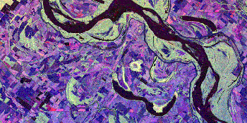
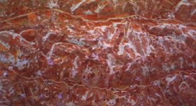 |
Fig. 1 - SAR image of Montespertoli area made
by combining P, L and C bands in HV polarization. |
Electromagnetic modelling
To enable a physical interpretation of the SAR interferometric data, a
coherent discrete-element model has been developed that predicts the backscattering,
coherence and interferometric phase centre position for observations of vegetation-covered
areas. The model coherently sums the fields diffused by the individual scatterers (disks
to simulate leaves, cylinders for stalks and trunks) and calculates the attenuation using
Foldy's approximation. All the individual contributions to scattering coming from the
individual scatterers and reflected from the ground are considered (Fig. 2). The model has
already been tested to simulate the interferometric response of wheat and sunflowers,
taken as examples of two crops with very different characteristics from each other.
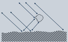 |
Fig. 2 - Contributions to total
backscattering considered in the electromagnetic model. |
Data analysis and results expected
The data obtained, both X-SAR and SIR-C, will
primarily be used to estimate heights, which are then compared with GPS measurements and
DEMs available for the test areas. Secondly, the interferometric data (amplitude,
coherence and phase) obtained by X-SAR (and if available by SIR-C) will be used to
identify the response type of various kinds of surface to the interferometric radar signal
using statistical relationships, and to compare the simulations with the experimental
data. In particular, penetration into forest and other vegetation types will be estimated
using the interferometric measurement and the electromagnetic model.
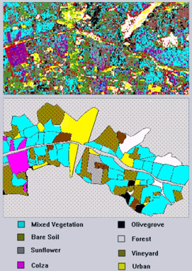 |
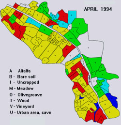
Fig. 3 - Example of
classification in Montespertoli area obtained from AIRSAR polarimetric multifrequency data
(top) compared with the facts on the ground (bottom). |
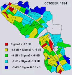
Fig.4 - Maps of backscattering coefficient for Montespertoli obtained from SIR-C
(band L pol HH) in April with mainly dry ground and in October with generally higher
humidity. |
|
|
|