
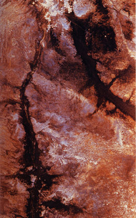
courtesy of NASA/JPL |
Wadi Kufra, Libya
Using different frequencies that can penetrate dry sand, SIR-C revealed
an unknown branch of an ancient river, buried under thousands of years of windblown sand,
in a region of the Sahara in southeast Libya, north Africa. The image shows inactive
stream valleys called paleodrainage systems, which carried water northward across the
desert during periods of wetter climate. Now hyperarid, the region receives only a few
millimeters of rainfall per year, and the valleys are dry wadis (channels), mostly buried
by sand. |
| The west branch of the paleodrainage system, the
Wadi Kufra (the dark channel along the left side of the image), was known and much of its
course outlined. The broader east branch, running from the upper center to the right edge
of the image, was unknown until SIR-C delineated its dimensions, which are at least 5 kilometers
(3 miles) wide and nearly 100 kilometers (62 miles) long. The two branches of Wadi Kufra
converge at the Kufra Oasis, the cluster of circular fields at the top of the image. Quite
likely, the water supply for the Kufra Oasis has been recharged by episodic runoff and by
groundwater that moved northward in the alluvial fill of the old stream channels. Rainfall
was more abundant here during parts of the tale quaternary period when paleolithic and
later neolithic people left their implements along the riverbanks. The SIR-C image
provides a "road map" for geoarchaeologists to locale artifacts and to better
interpret the history of early peoples and climatic conditions in this region. |
 |