
courtesy of NASA/JPL |
San Francisco, California
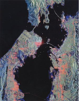
This image of san Francisco, California, shows how the radar distinguishes between
densely populated urban areas and nearby areas that are relatively unpopulated. Downtown
San Francisco is at the center and the city of Oakland is at the right across the San
Francisco Bay. Some city areas, such as San Francisco’s south of market, called the
soma district, appear bright red owing to the alignment of streets and buildings to the
incoming (from the right) radar beam. |
| Various bridges can be seen, including the
Golden Gate Bridge at the opening of San Francisco Bay, the bay bridge connecting San
Francisco and Oakland, and the San Mateo bridge. The dark areas are relatively smooth
water — the pacific ocean to the left, San Francisco bay in the center, and various
reservoirs. Two major faults bordering the San Francisco-Oakiand urban areas can be
discerned. The San Andreas fault, on the San Francisco peninsula, appears as a substantial
scar in the lower left. The fault trace is the straight feature filled with reservoirs of
water, which appear dark. The Hayward fault is the straight feature on the right side of
the image between the urban areas and the hillier terrain to the east. |
 |