
courtesy of NASA/JPL |
Vulcano Sakura-jima, Giappone
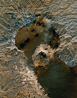
The active volcano Sakura-jima on the island of Kyushu, Japan is shown
in the center of this radar image. The volcano occupies the peninsula in the center of
Kagoshima Bay, which was formed by the explosion and collapse of an ancient predecessor of
today’s volcano. The volcano has been in near continuous eruption since 1955. Its
explosions of ash and gas are closely monitored by local authorities due to the proximity
of the city of Kagoshima across a narrow strait from the volcano’s center, shown
below and to the left of the central peninsula in this image. |
| City residents have grown accustomed to clearing
ash deposits from sidewalks, cars and buildings following Sakura-jima’s eruptions.
The volcano is one of 15 identified by scientists as potentially hazardous to local
populations, as part of the international Decade Volcano" program. The image was
acquired by the Spaceborne Imaging Radar-CIX-Band Synthetic Aperture Radar (SIR-CJX-SAR)
onboard the space shuttle Endeavour on October 9, 1994. SIR-C/X-SAR, a joint mission of
the German, Italian and the United States space agencies, is part of NASA’s Mission
to Planet Earth. The image is centered at 31.6 degrees North latitude and 130.6 degrees
East Iongitude. North is toward the upper left. The area shown measures 37.5 kilometers by
46.5 kilometers (23.3 miles by 28.8 miles). The colors in the image are assigned to
different frequencies and polarizations of the radar as follows: red is L-band vertically
transmitted, vertically received; green is the average of L-band vertically transmitted,
vertically received and C-band vertically transmitted, vertically received; blue is C-band
vertically transmitted, vertically received. |
 |