courtesy of NASA/JPL |
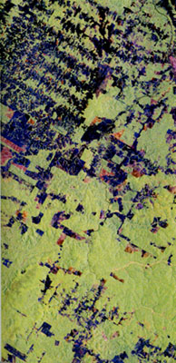
Rondonia, Brazil
Rondonia is located in the south central Amazon basin. Once an
underdeveloped frontier region with abundant, diverse tropical forest, the area has
undergone massive land-use change and deforestation in the last two decades. As a result
of colonization programs in 1968, development of a Trans-Amazon highway in 1984, and
continuous development projects for economic growth in the region, a major portion of the
tropical forest biome (ecological copvvv\uni1y) has been removed due to logging, burning,
ranching, and mining activities. A focus on deforestation, however, overlooks the fact
that burned and cut areas become conducive to rapid regrowth through sprouting, seed
survivals, and seed deposition by faunal and mechanical means. |
| Field studies indicate that, in some areas,
forest rebounds rapidly after cutting and burning because some species are tolerant of the
low nutrient stocks of the soils of Amazonia. Lack of data over the region has hampered
continuous analysis of the extent and rate of deforestation and regrowth, as well as
landuse changes in the area and other parts of the tropics — which, in turn, have
ecological, biological, climatic, and political ramifications. The brightest areas in the
image are pristine rainforest; darkest areas are the most recent clear-cuts. Some variable
tones are seen in clear-cut regrowth areas. |
