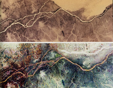
Nile River, Sudan These are two views, one photographic and one radar, of part of the Nile river, near the fourth cataract in Sudan. The top image is a photograph taken with infrared film from Space Shuttle Columbia in November 1995. The bottom image was acquired by the Sir-C radar in 1994. Image brightnesses are reversed in this radar image to emphasize subtle features. The thick white band in the top right of the radar image is an ancient channel of the Nile that is now buried under layers of sand. The channel is not evident in the infrared photograph and, in fact, its existence was not known before the radar image was processed. The area to the left in both images shows how the Nile is forced to flow through a chaotic set of fractures that causes the river to break into smaller channels, suggesting that the Nile has only recently established this course. Radar images have allowed scientists to develop new theories to explain the origin of the "great bend’ of the Nile in Sudan, where the river takes a broad turn to the southwest before resuming its northward course to the Mediterranean sea. |