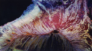
Mauna Loa, Hawaii
This image of Mauna Loa volcano on the Big Islands of
Hawaii shows the capability of imaging radar to map lava flows and other volcanic
structures. Mauna Loa has erupted more than 35 times since the islands was first visited
by westerners in the early 188's.
The large summit crater, called Mokuaweoweo Caldera, is clearly visible near the
center of the image. Leading away from the caldera (towards top right and lower center)
are the two main rift zones shown here in orange. Rift zones are areas of weakness within
the upper part of the volcano that are often ripped open as a new magma (molten rock)
approaches the surface at the start of an eruption. The most recent eruption of Mauna Loa
was in March and April 1984, when segments of the North East Rift Zones were active.
If the height of the volcano was measured from its base on the ocean floor instead of from
sea level, Mauna Loa would be the tallest mountain on Earth. Its peak (center of the
image) rises more of 8 kilometers (5 miles) above the ocean floor. The South Kona
District, known for cultivation of macadamia nuts and coffee, can be seen in the lower
left as white and blue areas along the coast. North is toward the upper left. The area
shows is 41.5 kilometres by 75 kilometres (25.7 miles by 46.5 miles), centered at 19.5
degrees north latitude and 155.6 degrees west longitude.
The image was acqired by the Spaceborne Imaging Radar-C/X- Band Synthetic Aperture Radar
(Sir-C/X-SAR) board the space shuttle Endeavour on its 36th orbit on October 2, 1994. The
radar illumination is from the left of the image. The colors in this image were obtained
using the following radar channels: red represents the L-band (horizzontally transmitted
and received); green represents the L-band (horizzontally transmitted, vertically
received). The resulting color combinations in this radar image are caused by differences
in surface roughness of the lava flows. The smoother pahoehoe flows arecdepicted in red,
and the rougher aa flows are shown in yellow and white.
Mauna Loa is one of 15 volcanoes worldwide that is being monitored by the scientific
community as an "International Decade Volcano" because of the hazard that it
represents to the local towns of Hilo and Kona. The Kilauea volcano is located off to the
right of Mauna Loa and is not visible in this image. |