
courtesy of NASA/JPL
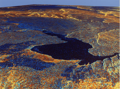
Long Valley, California
This three-dimensional perspective view of Long Valley, California was created from
data taken by the Spaceborne Imaging Radar-C/X-band Synthetic Aperture Radar on board the
space shuttle Endeavour. This image was constructed by overlaying color composite SIR-C
radar image on a digital elevation map. The digital elevation map was produced using radar
interferometry, a process by which radar data are acquired on different passes of the
space shuttle. The two data passes are compared to obtain elevation information.
The interferometry data were acquired on April 13, 1994 and on October 3, 1994, during the
first and second flights of the SIR-C/X-SAR instrument. The color composite radar image
was taken in October and was produced by assigning red to the C-band (horizontally
transmitted and vertically received) polarization; green to the C-band (vertically
transmitted and received) polarization; and blue to the ratio of the two data sets.
Blue areas in the image are smooth and yellow areas are rock outcrops with varying amounts
of snow and vegetation. The view is looking north along the northeastern edge of the Long
Valley caldera, a volcanic collapse feature created 750,000 years ago and the site of
continued subsurface activity. Crowley Lake is the large dark feature in the foreground.
 |