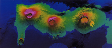
Isabela, Galapagos Islands This is a color composite image of Isla Isabela, one of the Galapagos Islands located off the western coast of Ecuador, South America. It was created by combining a radar image with a TOPSAR elevation map. The radar image was taken on the 4Oth orbit of space shuttle Endeavour by the Spaceborne Imaging Radar-C/X-Band Synthetic Aperture Radar (SIR-C/XSAR). TOPSAR is a prototype airborne interferometric radar which produces simultaneous image and elevation data. Color hues are used to indicate the height of the surface features; blue represents the lowest elevations and red-magenta the highest elevations. Wolf volcano, the tallest of the three pictured here, rises 1500 meters (5000 feet) above sea level. This image is centered at about 0.5 degree south latitude and 91 degrees west longitude and covers an area of 120 by 50 kilometers (72 by 30 miles). The radar incidence angle at the center of the image is about 20 degrees. The western Galapagos Islands, which lie about 1,200 kilometers (750 miles) west of Ecuador in the eastern Pacific, have six active volcanoes similar to the volcanoes found in Hawaii and reflect the volcanic processes that occur where the ocean floor is created. Since the time of Charles Darwin’s visit to the area in 1835, there have been more than 60 recorded eruptions on these volcanoes. This SIR-C/X-SAR image of Alcedo, Darwin, and Wolf volcanoes shows the rougher lava flows as bright features, while ash deposits and smooth pahoehoe lava flows appear dark. |