|
|
DataTake 1.070
Date: February 11, 2000
Zona: Border Arizona - New Mexico
This a view of the south east area of the Navajo Indian Reservation, close to the border between Arizona and New Mexico. The scene covers approximately 25km x 50km (16miles x 32 miles).
The images presented have been generated by an innovative Italian real time processor. The original four bit coded received raw signal is reformatted and recoded at one bit; then is processed in real time with a similar 1-bit code filter function. The filter convolution is implemented via a simple and inexpensive hardware consisting of phase shifters and adders. Downsizing and power reduction for this processor is possible, thus making the machine a good candidate for onboard processing.
The four images presented represent:
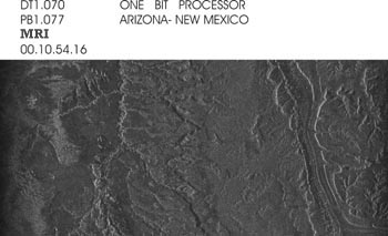
| Medium Resolution Image (MRI): the gray values represent the strength of the reflected radar signal; the stronger the back-scattering the brighter the image. Two such images are needed to obtain the Interferogram. | |
|
 |
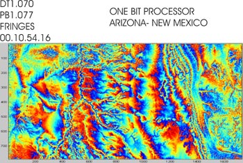
Interferogram: the different colors represent the different phase values; the steeper the slopes, the closer the fringes. Height contour levels can be inferred from fringes |
|
|
 |
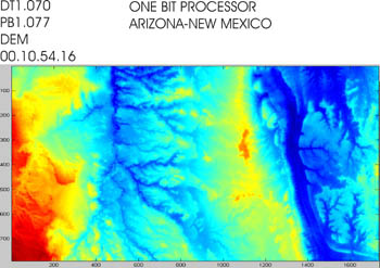
Digital Elevation Model (DEM): is a representation point by point of the surface height obtained from Interferogram; the height increases from blue to red. |
|
|
 |
DEM-3D: tri-dimensional view. |
|
|
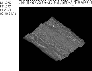 |
The DEM-3D shows steep mountains walls which can be also clearly seen from the close fringes on the interferogram. The same evaluations can be done looking to the DEM different colors.
These images were acquired by the Shuttle Radar Topography Mission (SRTM) aboard the Space Shuttle Endeavour launched on February 11,2000. SRTM uses the same radar instrument that comprises the Spaceborne Imaging Radar-C/X-band Synthetic Aperture Radar (SIR-C/X-SAR) that flew twice on the Space Shuttle Endeavour in 1994. The mission is designated to collect three dimensional measurements of nearly 80 percent of the earth surface. To collect the 3-D data , engineers added a 60 meter long (200 feet) mast, an additional C-band antenna and improved tracking and navigation devices. The mission is a cooperative project between the National Aeronautics and Space Administration (NASA), The National Imagery and Mapping Agency (NIMA) of the U.S. Department of Defense (DoD) and the German and Italian Space Agencies. It is managed by NASA’s Jet Propulsion Laboratory, Pasadena, CA, for NASA’s Earth Science Enterprise, Washington, DC.