The SRTM
mission history: the NASA SIR series and the Italian and German
experiences on space radar missions as precursors of the present mission
NASA/JPL's radar program began with Sea Surveillance
Satellite (SEASAT), the first spaceborne imaging radar, in 1978. SEASAT was a single
frequency (L-band; l ~ 24 cm), single polarization, fixed-look angle (20o)
radar, launched into a 108o inclination and an 800 km altitude orbit. The
purpose of the mission was oceanographic studies, but the radar images were also useful
for geological science. The mission ended after 100 days (due to a power system failure),
but many images were still returned. Approximately 108 sq. km were mapped.
The next four radar Earth-mapping missions were SIR-A on
STS-2 (11/81), SIR-B on STS-41G (10/84), and SRL-1 and SRL-2 (a combination of SIR-C and
X-SAR) on STS-59 and STS-68, respectively (4/94 and 10/94).
SIR-A was an L-band radar with a fixed look angle of 50o.
All SIR-A data were optically recorded and correlated. SIR-A imaged buried drainage
channels in southern Egypt, cloud covered regions, and dynamic ocean phenomenon. About 107
sq. km were imaged with a 50 km swath width and a 40 m resolution.
SIR-B added a variable look-angle capability and digital
image recorder to the L-band, single polarization radar. Images were recorded and
downlinked through the 46 Mb/s Tracking and Data Relay Satellite System (TDRSS) Ku
channels. Because of problems with the Ku system, the swath width varied from 10 km to 50
km. SIR-B generated the first stereo radar images, which were used to create 3-dimensional
topographic maps. The variable incidence angle was used to identify radar signatures of
different terrain and vegetation.
SIR-C provided increased capability acquiring digital
images simultaneously at two microwave wavelengths, L- band and C-band. These vertically
and horizontally-polarized transmitted waves were received on two separate channels, so
that SIR-C provided images of the magnitude of radar backscatter for four polarization
combinations: HH (Horizontally-transmitted, Horizontally-received), VV
(Vertically-transmitted, Vertically-received), HV, and VH; and also data on the relative
phase difference between the HH, VV, VH, and HV returns. This allowed derivation of the
complete scattering matrix of a scene on a pixel-by-pixel basis.
Germany's imaging radar program started with the Microwave
Remote Sensing Experiment (MRSE) flown aboard the first Spacelab mission in 1983. The
program was continued by development of the X-SAR, for which cooperation with Italy was
initiated.
The combined SIR-C/X-SAR system, otherwise known as SRL,
provided a capability to acquire images at three microwave wavelengths, L-band (l ~ 24 cm)
quad-polarization; C-band (l ~ 6 cm) quad- polarization; and X-band (l ~ 3 cm) single (VV)
polarization. Because radar backscatter is most strongly influenced by objects comparable
in size to the radar wavelength, this multifrequency capability provided information about
the Earth's surface over a wide range of scales not discernible with previous
single-wavelength experiments. SIR-C/X-SAR also had variable look angles, and could image
at incidence angles between 20o and 65o. Typical image sizes for
SIR-C data products were 50 km x 100 km, with resolution between 10 m and 25 m in both
dimensions.
In addition to the imaging modes required to accomplish
the scientific objectives of the SRL flights, a number of experimental modes were
incorporated into the SIR-C design for technology development. Among these was SCANSAR, a
technique for imaging across a very wide swath by electronically sweeping the radar beam
in the cross-track direction (perpendicular to the line of flight).
Using SCANSAR, SIR-C was able to
image at both C-band and L-band across a 250 km swath. It is this wide swath that makes
the SRTM mission possible.
One of the major accomplishments of the SRL flights was
the demonstration of "pass-to-pass" interferometry, a technique for measuring
the height of topography (or very small changes in that height). Figure 1 shows how data
from two imaging passes can be combined. The fundamental measurement produced by any SAR
is the range from the radar antenna to points on the ground, denoted for example by S1
in the figure. S1’ is the range to that same point measured on a different
imaging pass. Since the measurements are accurate to a fraction of a wavelength, the
difference S1 - S1’ for SIR-C or X-SAR can be determined to a
fraction of a centimeter. Of course, this so-called phase difference is modulated at each
point by the height of the topography. Given the spacecraft positions, the phase
difference for the case of perfectly smooth terrain can be predicted mathematically, any
residual present after this "smooth earth" function is subtracted is directly
proportional to the topographic height.
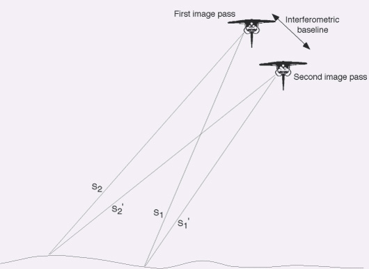
Fig. 1: Geometry for pass-to-pass interferometry
During the last three days of the SRL-2 mission, Flight
Dynamics Officers (FDOs) were successful in repeating the shuttle’s orbital path from
day-to-day almost exactly, necessary to minimize the interferometric baseline. Baselines
greater than about a kilometer would result in data that do not correlate well enough for
interferometry, but baselines of less than a few hundred meters were achieved and numerous
high quality topographic maps were generated using data from all three SIR-C/X-SAR
wavelengths.
|
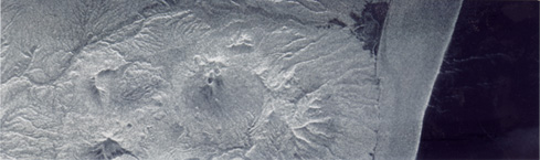
Immagine acquisita il 9
aprile 1994 con la prima missione X-SAR.
Si tratta del primo data take della missione ricevuto alle 19.41 (ora locale di
Huston) del 9.4.94 |
|
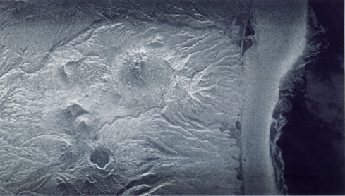
Immagine dello stesso sito
acquisita il giorno 11.4.1994 (D.T. 042.02) |
|
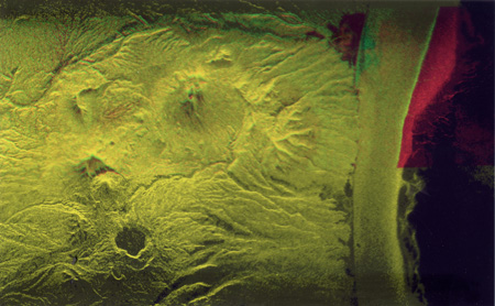
Immagine multitemporale
ottenuta sovrapponendo le due immagini precedenti,
dopo aver colorato la prima di rosso e la seconda di verde.
Le parti gialle sono quelle che non hanno subito variazioni
e quindi i due colori usati sono perfettamente compensati. |
Instead of pass-to-pass interferometry,
SRTM will use a 60-meter long space station-derived mast to perform fixed-baseline
interferometry. This fixed-baseline interferometry uses two separated antennae
simultaneously with one antenna transmitting radar pulses and both antennae receiving
echoes, so that only one data pass is required for each data swath. The transmitting
antennae will be located within the payload bay, as they were for the SRL missions, and
the receive-only antennae will be located at the end of the mast. This technique has the
advantages of avoiding temporal decorrelation caused by changes in the terrain between
imaging passes, of keeping the baseline separation between antennae constant, and of
keeping the antenna orientation well-determined.
|