| Experiment overview
The Shuttle Radar Topography Mission
(SRTM) is a dedicated Earth observation mission manifested for September 1999. SRTM is a
joint program among NASA, the Department of Defense (DoD), the National Imaging and
Mapping Agency (NIMA), and Deutsche Agentur Fur Raumfahartangelegenheiten GmbH (DARA).
SRTM is designed to use modified versions
of the Spaceborne Imaging Radar-C (SIR-C) and X-band Synthetic Aperture Radar (X-SAR) that
flew as part of the Space Radar Laboratory missions (SRL-1/ SRL-2 on STS-59/STS-68,
respectively) to map the topography of the Earth’s land surface. Unlike earlier
missions, SRTM will use single-pass interferometry, which means that two radar images will
be acquired at the same time -- one from the radar antennas in the payload bay, the other
from the radar antennas at the end of a 60-meter (200-foot) mast extending from the
shuttle. Combining the two images produces a single 3-D image. Both SIR-C and X-SAR will
be modified to operate as fixed-baseline interferometers with the objective of producing,
during a single 11-day shuttle flight, a digital topographic map of 80 percent of the
Earth’s land surface (all land area between 60° north and 56° south latitude, shown
in Figure 1), with data points spaced every 1 arc-second of latitude and longitude
(approximately 30 meters). The absolute horizontal and vertical accuracy will be 20 meters
and 16 meters, respectively.

Fig.1 - SRTM coverage
Mission objectives
SRTM has the objective of producing,
during a single 11-day shuttle flight:
- The most complete high-resolution digital
topographic database of the Earth. This translates to a map of 80% of Earth's land surface
(everything between approx. ±60° latitude) with data points spaced every one arc-second
with 10-meter relative vertical accuracy (16-meter absolute vertical accuracy).
- Data sufficient to produce an
orthorectified C-band mosaic of 80% of the Earth’s land surface at one arc-second
resolution.
- X-SAR data to produce high vertical
resolution, non-contiguous interferometric terrain height data in up to 50 km wide swaths
between ± 60° latitude with one arc-second latitude and longitude posting and 6 meter
relative vertical accuracy, (16 meter absolute vertical accuracy).
C-band data processing will be completed
within 1 year of the flight. SRTM mission requirements are summarized in Table 1-1.
Table -1. Mission
requirements
| Launch
date |
September
16, 1999 |
| Orbit
altitude |
126
n. mi. (233 km) |
| Inclination |
57o |
| Mission
duration |
11
days |
| Primary
landing site |
KSC |
| Crew
size/work shift |
6/dual |
Mission overview
For SRTM, both SIR-C and X-SAR will
operate as interferometers. SIR-C will only use the C-band system. (The L-band system is
not required for topographic mapping but will be retained as a backup imaging method.)
X-SAR will operate simultaneously with SIR-C.
Nominal Radar Operations
To meet mapping requirements, SRTM must
collect data over at least a 225 km swath. To accomplish this, both the inboard and
outboard antennae will operate in SCANSAR mode with one refinement. Instead of a single
beam scanning across track, SIR-C will use two polarizations (HH and VV) to form two beams
from each antenna. Thus, two of the four subswaths will be illuminated at all times, as
shown in Figure 2. This mode is referred to as two-beam SCANSAR. In this way all four
SIR-C channels can be used and the additional polarization will provide a single-beam
backup mode at slightly reduced resolution.
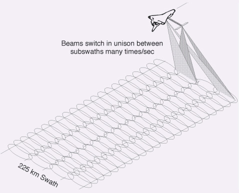
Fig. 2: Two-beam SCANSAR
X-SAR will use a single beam for each
antenna with VV polarization. The X-SAR image will be of higher resolution than SIR-C,
although the narrower 50 km swath prevents global coverage. The X-SAR swath will be placed
between the third and fourth SIR-C subswaths, as shown in Figure 3, to provide additional
data where the SIR-C data transition from horizontal to vertical polarization.
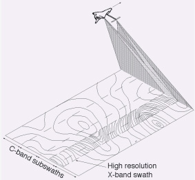
Fig. 3 - Arrangement of
SIR-C and X-SAR swaths
Backup Radar Operation Modes
If for some reason the two
polarization SCANSAR mode cannot operate, three backup modes have been defined to provide
flexibility for the operations team to achieve as many of the mission objectives as
possible.
1. Single-beam SCANSAR, 20MHz
In the case of a failure of one of the C-band polarizations, SIR-C could still operate as
a single-beam, single polarization SCANSAR interferometer and collect topographic data. In
this mode a 20 MHz bandwidth would be used, filling the four available data channels.
Expected performance would be comparable to the nominal mode. The X-band interferometer
would be unaffected.
2. Single-beam SCANSAR, 10 MHz
In the case of a failure of one of the C-band polarizations, SIR-C could also operate in a
10 MHz mode. However, this mode would only require two data channels. So the
cross-polarized C-band image data, as well as a single channel of L-band image data, could
be collected simultaneously.
3. Image-only SCANSAR
If for some reason the mast failed to deploy or the remote antennae failed to operate,
SIR-C could still acquire dual-frequency, dual polarization image maps of the world, with
X-SAR operating in image-only mode.
Mission Description
SRTM will primarily be operated from the
Johnson Space Center (JSC) Payload Operations Control Center (POCC). Mission planning, as
well as generation and uplink of commands to SRTM, will be greatly simplified compared to
past SRL missions. This is possible because in a nominal mission there will be only one
mode of operation (interferometric SCANSAR for SIR-C, interferometry for X-SAR). The crew
must activate and configure the experiment electronics and antennae, as well as perform
tape changeouts from the Payload High Rate Recorders (PHRRs). Ground commands (from the
JSC POCC) initiate data takes. The crew will stow the antenna and deactivate the
electronics at the end of the mission.
For nominal on-orbit operations:
1. The crew performs the MDM pallet
activation.
2. The crew activates SIR-C and X-SAR.
3. The crew sets up the AODA Processing
Computer (APC) and Recorder Interface Controller (RIC).
4. The crew performs the on-orbit checkout
and deploy of the mast and antennae.
The ground will uplink up to 24 hours of
experiment commands to be stored in the SIR-C or X-SAR command sequencers. Commands may
also be uplinked in real time to the command buffers.
The uplinked commands are generated by
POCC Experiment Ground Support Equipment (EGSE), based on premission state vectors and
timelines. Orbit changes or mission anomalies could result in extensive replanning
efforts. The EGSE has the flexibility to replan experiments within mission constraints and
safety rules, uplink availability, and TDRSS availability.
For off-nominal on-orbit operations:
1. The crew can perform MDM pallet
activation to reconfigure SIR-C to selected redundant subsystems.
2. The crew can recalibrate the milkstool.
3. The crew can perform an emergency stow
or jettison of the mast.
4.The crew can replace a high rate
recorder and/or power supply.
When the mission is complete, the crew
will stow the mast/antenna assembly and then deactivate the SRTM experiment subsystems and
MDM pallet. |